Myslinka is a small village c. 5 km west of Pilsen on a gentle north-facing slope above the Myslinka stream at an altitude of 360-380 m. The village was first documented in 1239, when it became part of the large estate of the local Benedictine monastery in Kladruby. When the monastery was burnt down during the Hussite Wars (1419-1434), the estate was devastated and a number of villages depopulated, including Myslinka. The monastery reclaimed the estate and restored it to prosperity after the Thirty Years’ War (1618-1648), with the settlement of Myslinka re-established sometime after 1671 (Gersdorfová 2020, 1-2). The settlement pattern then included the large monastic manor farm cultivating most of the cadastral territory and 17 small farms with strip fields in marginal areas, settled by invited peasants whom parish registers indicate were German.
The number of houses increased steadily from 19 in 1789 to 38 in 1930, when about 80% of inhabitants were German farmers and the remainder landless Czech agricultural workers. After WWII, residents of German ethnicity were expelled and their property given to Czech settlers. The manor farm and its fields were nationalized in 1948 and managed as a state enterprise with the collectivization of private farms starting in 1950. The village, which had 36 houses in the 1980s, began to grow again after the Velvet Revolution (1989) and currently has 59 houses accommodating 225 inhabitants (Gersdorfová 2020).
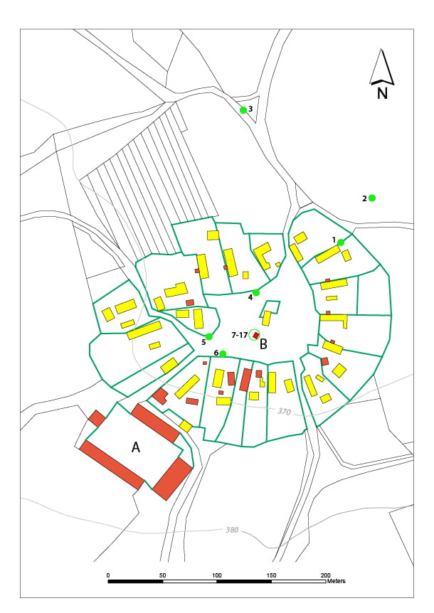
The earliest ordnance survey map of Myslinka from the late eighteenth century (http://oldmaps.geolab.cz/map) depicts an oval plan, with more detail shown on the cadastral map from 1838 (https://archivnimapy.cuzk.cz), with 20 small farms situated around the central village green with a small chapel. A large baroque stone and brick monastic manor-farm on the south-east, and farm buildings probably using the corner-timbered construction style typical of this part of West Bohemia (Vařeka and Frolec 2007; 2010) were replaced in the late 19th/20th century by stone and brick buildings, with new houses added on the northern side of the village. During the communist era, several buildings were demolished including most of the manor house and chapel.
References
Krajíc, R., Měřínský, Z. and Vařeka, P. 2017: Archaeology of the 16th-20th century in the Czech Republic. Archaeologia Historica 42, 367-399.
Nováček, K. and Vařeka, P. 1996. ‘Archaeological research of present-day villages of a medieval origin in Bohemia’ in J. Fridrich, J. Klápště, Z. Smetánka and P. Sommer (eds.), Ruralia 1, Památky archeologické – Supplementum 5. Prague: Institute of Archaeology Academy of Sciences of the Czech Republic. 314–316.
Vařeka, P. 2020. Archaeology of the St Nicholas Church in the demolished village of Libkovice (Liquitz) – Excavations in 1995-96 (North Bohemian brown coal mining area). A contribution to the research of medieval village churches in Bohemia. Archaeologia historica 45, 1, 2020, 185–202
Vařeka, P., Kostrouch, F., Kočár, P. and Sůvová, Z. 2010. Příspěvek ke studiu žijících vsí středověkého původu. Pozůstatky zástavby z pozdního středověku na parcele č.p. 121 v Mikulčicích – A contribution to research of existing villages of medieval origin. The remains of the late medieval buildings on house plot no. 121 in Mikulčice. Přehled Výzkumů 51, 249–265.